|
|
 |
Historic Hurricanes |
 |
William G. Lesso
blesso@mail.utexas.edu
July 2004 |
 |
This program was started in the mid 1970's as a follow on to a
hurricane damage model developed by the author, for the Texas
Coastal and Marine Council. This agency was supporting a bill
in the Texas Legislature that required homes being built in the
19 coastal counties of Texas meet a new standard of withstanding
140 mph winds. The current standard was 104 mph. It was felt that
homes built to the new standard would suffer 50% less damage.
To build to the new standard would increase the coast of the building
by 0.5 to 1.5 %. Of course, many of the homes on the coast were
built to no standard. In the course of that work, the author visited
the National Hurricane Center to obtain data for the damage simulation
model. There he met with Dr Herb Saffir, one of the leading experts
on hurricanes and wind damage. Dr. Saffir was coauthor of the
Saffir-Simpson scale for hurricanes. Later, the National Hurricane
Center (NHC) provided the author with a tape that contained historical
data on over 700 tropical storms dating back to 1886. This data
was used to develop the first forecasting models. (Note: The building
standard bill did not pass. The Real Estate lobby was more powerful
than the Insurance lobby!)
Hurricanes are said to be the most powerful and deadly of nature’s phenomena.
Besides winds that can exceed 200 mph, they generate storm surges that can exceed
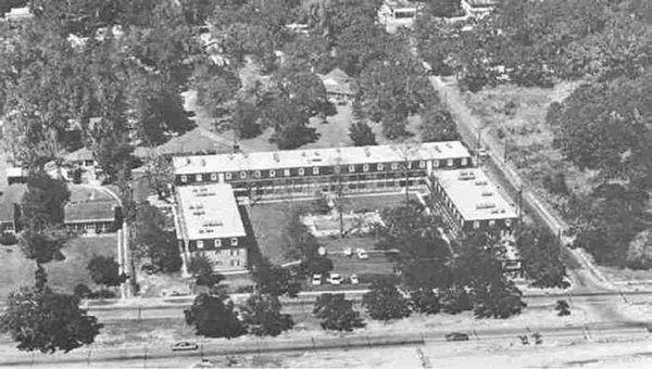
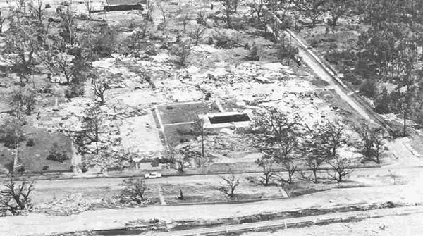
35 feet. One example of this was Hurricane Camille in 1968. It hit the town of
Port Christian, Mississippi with a 30-foot surge of water. A group of 30 or more
people were having a ‘hurricane’ party on the third floor of the
Richelieu Apartments. |
|
| |
When the storm surge hit, all
the people were swept out of the building. All but one perished.
She was found in a tree several miles down the coast.
|
|
| |
The movement of hurricanes is
often unpredictable. The author, while being interviewed for
a newspaper article in the 1980s commented on this and said, “That’s
why they are named after women.” The lady reporter retorted, “Young
man. Women are NOT unpredictable! They just reserve the right
to change their mind!”
A good example of this is Hurricane BARRY (1983). It was
proceeding north off the east coast of Florida. Just opposite
Cape Canaveral with a space shuttle
on the pad, it made a 90-degree left turn. (Perhaps it wanted to check out
the shuttle!) It then proceeded to cross Florida and enter
the Gulf of Mexico. It
gathered more strength and eventually hit Brownville, Texas. (I got a call
from a radio station in Brownsville at 4 AM asking where
the storm was. I suggested
politely that they look out their window. Barry is one of the storms in the
HISTORIC HURRICANE set in the Excel data file historic_hurricane.xls.
If one looks at the comments about these storms, two factors become apparent.
Except of the Hurricane of 1900 that killed 600 people, there are few deaths
in the US and many on the Caribbean Islands. There is little dame on the Islands
and a lot in the US. A possible explanation for the first is that we have improved
our warning capability and the population has time to evacuate AND they have
someplace to go. The poor people on the Islands are trapped! Likewise there
is less infrastructure on the Islands and much along the US coast. We love
to live
on the seashore! |
The First Models |
| |
The hurricane wind damage model
was presented as a technical paper by the author at a national
conference on hurricanes. One of the speakers from the NHC
announced that one of the primary forecasting models in use
at that time gave results two and three quarter hours after
they obtained a position report on the eye of the hurricane,
instead of three hours and fifteen minutes. (Its hard to remember
that computers in the late 1970 were so slow compared to what
we have today!) A portion of the audience cheered. Later we
found out that forecasters were to give their forecasts three
hours after the position report and then wait another fifteen
minutes to see how wrong they were.
The first models described the movement of hurricanes as a
Markov process – a “random
walk” in two dimensions. During the course of a graduate seminar on ‘Problems
in Operations Research,’ the author described the hurricane damage model
that had been presented and the incident of the ‘quicker’ forecasts
from the NHC. The author made the boast, “If I couldn’t do better
than that, I’d eat their computer tape of data!” One of the graduate
students suggested that we use a Markov process. As he said, “ After all,
a hurricane is much like a two-dimensional random walk!” Originally four
separate models were tried. Two were soon abandoned as too cumbersome. Later
the features of the other two were combined into the basis of the current model.
The first version of the model had the characteristic of being
either very “good” or
very “bad” with no prior indication of what mode it would be in.
The criterion used to evaluate the model were a standard proposed by the NHC
in the 1970’s. Their goal was to have the mean position error for the 72
hour (3 day forecast) to be less than 125 nautical miles. At that time, their
actual mean position error for 72 hours was about 375 nm.
For the original model, when it was “good”, the mean position error
was less than 100 nm and when it was “bad” the error was over 500
nm. After several attempts to improve the model, Dr Tom Curry, as his PhD dissertation,
developed a modified Markov process model and gave consistent results. Currently
the mean position error for the model is about 175nm for the 72 hr forecast.
|
The Next Model |
| |
The model uses position reports
of latitude and longitude as provided by the National Weather
Service. At the time the model was constructed, these position
reports were given every 6 hours. For a Markov process the
probability of the system being in any state depends only on
the previous state. The process is said to have a memory of
one. Translating this to the movement of hurricanes, the process
can be defined as: “The probability that a hurricane
is at any given position (Latitude and Longitude) at a given
time, only depends on where it was at some previous period
of time. Since we are interested in movement, this implies
distance and direction. To achieve this, we need to use the
previous TWO six hour positions of the hurricane. These give
is a measure of the average velocity it traveled and the direction.
The model did not just simply project this movement in a straight
line but used a probability table for possible locations based
on the latest latitude and longitude.
As mentioned previously, the initial models were either very
good or very poor. During the research work of Dr. Tom Curry,
we discovered we needed to include
a “steering” effect based on the diurnal movement of storms, i.e.
they slowed down at night and sped up during the day. So the Markov process was
modified to include the position report of the storm 24 hours previous to the
latest position. Also, at this time we found a way to collapse the massive probability
transition matrix of possible latitudes and longitudes based on the latest position
to a set of regression equations simply based on latitude. These greatly simplified
the running of the model.
The model requires a minimum of five six-hour position reports
of latitude and longitude. The model will then project the
movement of the center of the storm
for the next 90 hours, in six-hour increments. As additional position reports
are obtained they are entered to update the projections.
This version of the model was programmed in the late 1970’s and updated
with features from time to time. As such it is characteristic of the types of
programs written at the time with a Main menu page with a series of options.
There is a catalog of storm data for past storms. The error analysis option was
not operable on this version since it was used in the early running of the model
to determine the mean position error at 6-hour intervals. Two of the major features
added to the model were the set of forecasting equations cited above and a plot
option that shows the forecasted movement of the storm.
|
The Current Model |
| |
The model was not been updated
in the last fifteen years to incorporate the current mode of “pull-down” menus
or different forecasting intervals. Over the past several years
the NWS has at times issued position reports at 3-hour intervals
and even 2-hour intervals. The current model can only use 6-hour
increments. Where there are 3-hour reports, the ploy we have
used is to run two series of forecast, e.g. Hugo-A and Hugo-B
and run them alternately as the reports come in. As a point
of interest, the error in forecasting the landfall of Hugo
72 hours
in advance was less than 30 nm.
In 2004, Dr. Paul Jensen implemented the model using the Visual
Basic for Applications (VBA) macro language for Microsoft EXCEL.
This version incorporates a plotting
function using maps. Also, the error analysis function is made fully operational.
A full description on the use of the model and a file of ‘Historic Hurricanes’ can
be found on this website.
|
|
|
| |
Early in the research into hurricane
movement, two characteristics became apparent. First, storms
have a diurnal cycle. They slow down at night and speed up
during daylight hours due to the energy absorption from the
sun. This characteristic is modeled in part by having the forecast
depend on the five-step-back position that tells the location
one day back.
The second characteristic became apparent through the examination
of a sequence of satellite photos. These gave the same
effect as watching a movie film. They
showed that the eye of the hurricane pulses and wobbles. The pulsing was perhaps
due to the diurnal effect. The wobble had the appearance of following a cycloid
path. That is, the path a point on a wheel would follow as the wheel rolls
along. This wobble has the effect of introducing an error
in the forecasts. Since the
position reports are taken every six hours (every three hours as the storm
approaches land), the direction of movement could be off
depending on where the storm was
in the cycloid cycle. If the characteristic of this wobble could be determined
by estimating the parameters of the equation of the cycloid, then a correction
could be made and the accuracy of the forecast might be improved. This is the
direction of current studies.
|

|